I’ve been writing a lot about certain aspects of my project here, but I’m actually not sure if I’ve ever written anything about the project as a whole. What it is all about. What are all these transect walks good for? Why has Elli dug up all this soil? What are we even here for? Well, now that we’re back in the (relative) luxury of Ouagadougou, I thought it would be good practice for me to tell you a little bit about the research, both because it’ll give you context and you might find it interesting, but also because it is good for me to actually describe what I’m doing in lay terms, outside of the scientific-resilience bubble that I’m living in. So, here’s my attempt at making it understandable.
The Project
Elli and I are both part of a bigger project that is run by the Landscapes theme at Stockholm Resilience Centre in collaboration with researchers from SEI, the human geography department at Stockholm University, and INERA, a governmental research institute here in Burkina Faso focused on agriculture.
The project was started parallell to a number of other research projects on the so-called re-greening Sahel. Basically, some time ago, some remote sensing people noticed that parts of mostly western Sahel had seen an increase in biomass during the last couple of decades (based on satellite image data) that could not be explained by changes in percipitation. This has led to a number of different kinds of studies on what this increase in biomass actually means, on the ground.
Our project focuses on the impact on humans of the re-greening through studying ecosystem services and their connection to different parts of the landscape.
Ecosystem services is a concept that can be used to clarify different kinds of services that are provided by ecosystems to society, such as clean water or pollination. Services that might not be possible to put a price tag on but that are essential nonetheless. It is not a completely uncontroversial concept, and there are definite problems with it, but I personally think that its pragmatic approach to making ecosystem processes understandable from a societal point of view definitely holds potential.
What part of this SRC Re-greening Sahel project has tried to map, are a type of ecosystem services called provisioning services, that is, services that are directly beneficial to people. It can be anything from farmed crops to grass that animals can graze, and they are generally the most straigtforward to identify.
Most people here in Burkina Faso are reliant on the land for their livelihoods, and the landscape is multifunctional. Basically, people get a big variety of things from the ecosystems around them. Therefore, to understand this multifunctionality better, and its importance for the resilience of peoples livelihoods, the project has developed a new concept called ecotopes. They are landscape types that provide a certain set of provisioning ecosystem services. A PhD student, Hanna, together with my supervisor and some other researchers, have identified the services and ecotopes, and then made detailed maps of the ecotopes in six villages here in northern Burkina Faso. This is useful, because it can illuminate the spread of ecosystem services in the landscape, where they are physically provided and what there might be a lot or very little of.
My project
This is where my project comes in. Hanna’s ecotopes and the maps that she has made are very detailed and have been very time-consuming to produce. To be useful for policy and management, the results need to be made more large-scale. So, my task is to investigate, first, if these ecotopes can be generalized on a more regional scale here (do the same kinds of landscape types provide the same ecosystem services to people?), and second, is it possible to make a regional scale mapping of the ecotopes using free satellite imagery (that is, a landcover/land use classification of Landsat images).
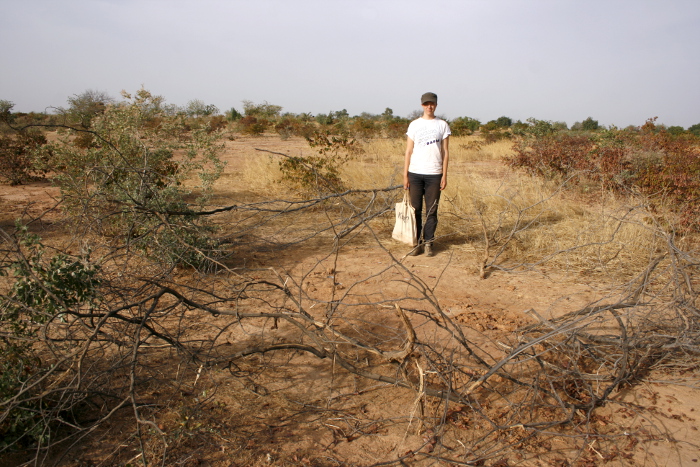
To do this, I have been doing participatory transect walks. Generally, in remote sensing, groundtruthing is done through visits to random points in the study area. The degree of correspondence between the ”ground truth” and the classified map gives a percentage on the accuracy of the map.
However, this is not possible here. First, because many areas are inaccessible by car here, and second, because going to random points without knowing the context of the place would completely make me miss the social relevance of it. Therefore, I have chosen a number of random villages. In these villages, I have (and still will) gone on walks with 1-4 villagers, two walks per village, and asked them questions about the things that we see, while taking GPS points, photographs and notes. By doing this, I have tried to get an understanding for both the ecosystem services provided in the different places, at the same time as getting socially relevant groundtruthing points for checking the accuracy of my satellite image classification.
This has been exhausting work, walking about 10 kilometers per village in the ruthless Sahelian sun, forcing thorny shrubs and inhospitable, stoney hills. This far, I have done eight villages. In two weeks, I will have done five more. But even though every walk completely drains me, and the questions that I ask have started to bore me (because, luckily for the project, the answers that people give me are very similar), but I can still enjoy it. I like walking. And I like landscapes. I know that sounds incredibly vague, landscapes, that’s just like saying I like the whole Earth. But I like how flowers and trees and hills make up a whole, I like exploring the nuances, I like seeing how all these details make up a fabric where people and animals can live. And how they live. Most of the time I don’t know what I’m doing, scientifically speaking, but be as it may with that. At least I got some personal enjoyment out of my fieldwork.
The participatory aspect of my method is that I walk with the villagers. However, it is easy that things get misunderstood in interviews, especially if there are culture differences and language barriers involved. Therefore, I have chosen (after being recommended to do so by a human geography researcher in the Re-greening Sahel team) to quickly do a first, preliminary analysis of my gathered data, and then return to the villages and present it, to make sure that they agree with my interpretation of things. With me, as a presentation of my results, I’ve brought photographs of the different ecotopes and a map sketch made in Google Maps where our transect paths and the ecotopes that we saw have been added on top of a high resolution satellite image. There’s been a lot of cut-and-pasting going on to produce them, and the printing facilities in Ouahigouya were very limited, so I was forced to show the map sketches on my tablet. But, surprisingly enough, it has worked. The villagers have looked at the map sketch solemnly, with interest, and nodded in recognition when I’ve explained where different places are situated on it.
I’ve also shown them the photos of some typical examples of the ecotopes, and explained what I think the uses in them are. Mostly the villagers have agreed with my analysis, but there has always been some small addition, maybe, or clarifications. The existence of dams in some of the villages has led to some discussions, and the degree to which they use different ecotopes to pick wild fruits and medicinal plants seem to differ a bit.
When I first decided to do these feedback sessions in the villages, I didn’t really know how to approach the meeting. On the one hand, it is important to make sure I’ve understood things, and to give the villagers an opportunity to correct me if I’ve misunderstood. But there is also the issue of putting things on a good, understandable level. I couldn’t go in and talk about the theoretical framework of ecosystem services – but I didn’t want my feedback to be just self-evident things that they all already knew either. Actually, I was quite nervous.
It turned out, though, that I wouldn’t really have had to. People in the villages are incredibly knowledgeable about the land, and their memories are amazing when it concerns what has happened there. They also seem to find anything that concerns the land interesting, which isn’t really weird considering that most of their lives revolves around it. In some villages, this checking session even developed into a more general discussion about the state of things, or about science. In one village, I ended up giving a basic explanation of remote sensing, vegetation monitoring and the re-greening Sahel in particular. And in another village, I ended up presenting the whole SRC Re-Greening project and how all the different pieces of it fit together. These sessions were almost my favorite parts of this entire trip so far. The villagers all seemed so interested and they were so appreciative, thanking me for having come to their village, and wishing me good luck in my work and saying that they were praying for my success, and that it in the future might lead to good things for the entire region.


It is both exhilarating and scary, having people putting so much faith in me. I have a responsibility, now, to make sure I make something good with this thesis of mine. I’m not the only one with a vested interest.
Elli’s project
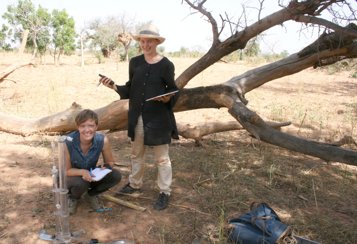
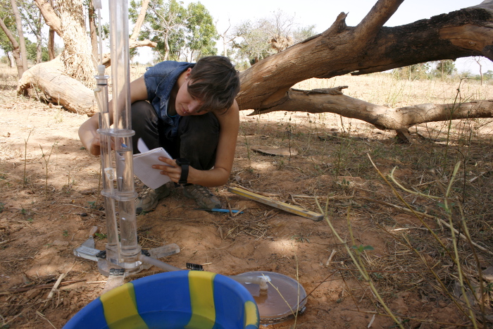
If I am here to try to scale up the results of Hanna, Elli is here to dive into the details. She is looking at indicators for another group of ecosystem services called regulating, and here in particular the ones connected to the soil, to see how they are related to the ecotopes. She’s taken soil samples, for measuring of nutrients, among other things. She’s also measured evaporation using lysimeters made from PVC-pipes in our Ouahigouya hotel room, and water infiltration using an tension infiltrometer. Watching the water slowly float to the surface.
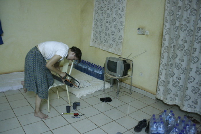
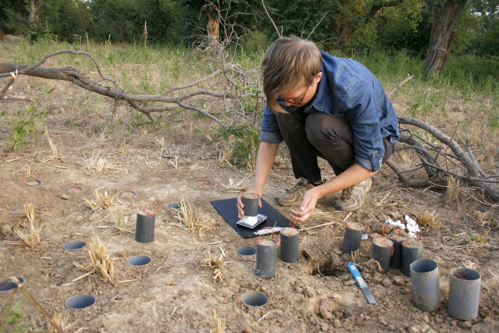
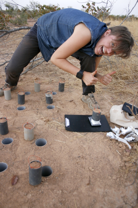
Elli, happily weighing her last lysimeter on her last day of evaporation measurements.
They are quite different, our projects, one involving shovels and tubes, and the other one a GPS and a camera. But we’re still reaching for the same goal, and in the end it will all hopefully become a neat, not very little whole.
Either way, she’s been an incredible support for me here and it is of course impossible to say, but, I feel like I wouldn’t have been able to do this work without her. Not going alone is the best almost chance thing that could have happened to my fieldwork experience.